


Bois de Païolive 14/10/21

Linerou
User
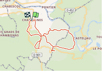

Length
9.9 km

Max alt
251 m

Uphill gradient
229 m
Km-Effort
13 km

Min alt
149 m

Downhill gradient
221 m
Boucle
Yes
Creation date :
2021-10-14 07:55:30.744
Updated on :
2021-10-14 13:35:38.573
3h23
Difficulty : Medium

FREE GPS app for hiking
 SityTrail
IGN / Geographical institutes
SityTrail Plus
The world is yours!
About
Trail Walking of 9.9 km to be discovered at Auvergne-Rhône-Alpes, Ardèche, Les Vans. This trail is proposed by Linerou.
Positioning
Country:
France
Region :
Auvergne-Rhône-Alpes
Department/Province :
Ardèche
Municipality :
Les Vans
Location:
Chassagnes
Start:(Dec)
Start:(UTM)
592832 ; 4917821 (31T) N.
Comments